
Land for Sale
Land Acreage For Sale In California – 2.27 Acres Hwy 299E Bella Vista $29,900
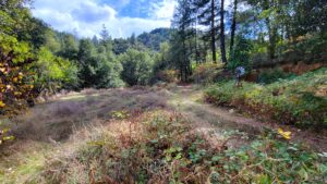
Check out the YouTube Land Video for a great boots on the ground feel. Located in the historic town of Ingot, where in 1862 the old timers mined for silver, copper, and zinc. There is a short dirt road entrance off the hwy located just after the Ingot, CA Auto Wrecker. There is a decent level area with the foundation of a shed started and there is an unpermitted shallow hand dug well right around the property line give or take, hard to say it’s exact location without a surveyor. Some properties in this area are also getting government funding for old mine/mineral remanence cleanup from the EPA in the form of a Super Fund. (No cost to owner according to the EPA) This property adjoins 292 acres of BLM land to the Northwest that you may want to explore. The BLM land has at least one old cave or mine on it. The elevation ranges from 1120 to 1200 feet, below the snow.
| Directions | Hwy 299E from Redding, CA. From the My T Fine Food Store in in Bella Vista on Hwy 299 go east 11.5 miles. Go left just after the corrugated metal fencing to the dirt path leading up hill. | ||
Apn’s: 097-060-007, 009, 010, 020
Approx. GPS:
| Latitude | 40.728836 | Longitude | -122.077431 |
| Price | $29,900 |
|---|---|
| Location | Bella Vista, CA |
| Lot Size | 2.27 Acres |
| Status | For Sale |

Off The Grid Land For Sale In California off Miller Mountain Rd Whitmore $32K
Check out the YouTube Land Video for a great boots on the ground feel. Affordable off the grid land ready for your recreational escape–whether you enjoy target shooting, hunting, or simply unwinding in a hammock under the trees. Situated at approximately 2,600-2,900 feet in elevation, the property offers noticeably cooler temperatures than the valley below. The setting provides a sense of privacy and seclusion, making it an ideal spot to get away from it all. Access is best suited for vehicles with higher ground clearance, and all-wheel drive is recommended. Seller Financing is not available.
Directions: Hwy44E past central Palo Cedro. Left on Old 44 Dr. Right on Whitmore Rd go 17.7 mi. Left on Fern Rd go 2.3 miles. Right on Miller Mountain Rd (small sign, wide turn out) go 1/2 mile. Right on no name road and go 1.1 miles to property and pink tape, just past old white Subaru.
APN: 099-370-024-000, 099-370-025-000, 099-370-023-000
Approx. GPS:
| Latitude | 40.652059 | Longitude | -121.867473 |
| Price | $32,000 |
|---|---|
| Location | Whitmore, CA |
| Lot Size | 15 Acres |
| Status | For Sale |

Land For Sale In California 8.69 Acres Ole Ave Manton, CA $45K
Check out the YouTube Video for a great boots on the ground feel. Discover this exquisite 8.6 acre parcel out in the peaceful rural setting just south of Shingletown, CA off hwy 44E. The land boasts a lot of flat terrain making the land extremely useable. There is a creek on the property and an old vehicle and mobile home of no value. There is also the Cross Country Ditch meandering through the property which serves local residences and winery’s. Situated at an elevation of just over 2,000 feet. Close by is a wild horse sanctuary and local wine vineyards. Not too far is Lassen National Park for outdoor activities or Eskimo Hill if you like to slide down snowy slopes. In addition, Burney Falls is a site worth seeing with its 129 foot waterfall and hiking trails. If you are into fly fishing, famous spring fed Hat Creek in Hat Creek, CA is the place to go for some of the best trophy trout. This property is about 32 miles from Redding, CA. Seller Financing is not available.
Directions: I-5 to Hwy 44E in Redding. Go to Shingletown, CA. Right on Wilson Hill Rd go 7.3 mi. Right on Rock Creek Rd, go .2 mi keeping straight on road to pink tape on locked green gate before Water Ditch.
APN: 703-240-010-000
| Price | $45,000 |
|---|---|
| Location | Manton, CA |
| Lot Size | 8.69 Acres |
| Status | For Sale |

Land For Sale In California – 18330 Morning Dew Rd Cottonwood, CA $68k
Check out the YouTube Video for a great boots on the ground feel. Discover this exceptional 8.29-acre parcel nestled in the scenic Quail Ridge Subdivision. The land features gently rolling terrain dotted with majestic blue oak trees, creating a peaceful and picturesque setting. Situated at an elevation of approximately 600–650 feet, the property enjoys a mild climate where snowfall is rare. A seasonal creek with waterfall meanders through both the northwest and northeast corners of the property, adding soothing natural ambiance with its gentle sights and sounds. The captivating landscape offers both privacy and tranquility—an ideal setting for your dream home. The property is served by power and fronts a paved road for convenient, year-round access. CCRs are in place, along with an HOA fee of approximately $350 per year. The property is just 13 miles to the Holiday Market in Cottonwood, CA. Seller financing is not available.
Directions: I-5 Exit Hooker Creek Rd go west 3.4 miles. Left on Quail Ridge Rd go 2.2 miles. Left on Pack Saddle Rd. Left on Morning Dew Rd property and pink tape on left just after house.
APN: 007-550-059-000
Approx GPS:
| Latitude | 40.295984 | Longitude | -122.356349 |
| Price | $68000 |
|---|---|
| Location | Cottonwood, CA |
| Lot Size | 8.29 Acres |
| Status | For Sale |

Land For Sale In California – 10789 Beehive Rd Redding, CA $68K
Check out the YouTube Video for a great boots on the ground feel. Build or set your manufactured home on this improved land. Located outside of Redding’s city center for a more private feel, this 1.6 acres sits on level to rolling ground making it usable and has super easy access from paved Iron mountain Rd. There is power at the lot line, a septic system installed, and community water provided by Shasta Community Services District. This property burned in the 2018 Carr Fire. The elevation is about 730 feet. The zoning is rural residential. Just 5 miles from the downtown Redding Holiday Market and much more. Whiskeytown Lake is just a few miles further up Hwy 299 and is perfect for boating, hiking to waterfalls, swimming or relaxing on the beach.
Directions: Hwy 299W from downtown Redding. Go 1.9 from the Grocery Outlet Store. Right on Iron Mountain Rd go 1.2 miles. Right on Sanders (no sign) before the mailboxes. Stay right at split. Property, sign and pink tape on the left.
APN: 065-280-014-000
Approx. GPS:
| Latitude | 40.602381 | Longitude | -122.462209 |
| Price | $68,000 |
|---|---|
| Location | Redding, CA |
| Lot Size | 1.6 Acres |
| Status | For Sale |

Land For Sale In California, 9.2 Acres Rock Creek Rd, Manton. $69K
Check out the YouTube Video for a great boots on the ground feel. Discover this exquisite 9.2 acre parcel out in the peaceful rural setting just south of Shingletown, CA off hwy 44E. The land boasts pretty much flat terrain making the land extremely useable. Situated at an elevation of approximately 2,000 feet. Close by is a wild horse sanctuary and local wine vineyards.
Not too far is Lassen National Park for outdoor activities or Eskimo Hill if you like to slide down snowy slopes. In addition, Burney Falls is a site worth seeing with its 129 foot waterfall and hiking trails. If you are into fly fishing, famous spring fed Hat Creek in Hat Creek, CA is the place to go for some of the best trophy trout. This property is about 30 miles from Redding, CA.
Directions: I-5 to Hwy 44E in Redding. Go to Shingletown, CA. Right on Wilson Hill Rd go 7.3 mi. Right on Rock Creek Rd. Property on left at pink tape and RE sign.
APN: 703-240-015-000
Approx. GPS:
| Latitude | 40.442965 | Longitude | -121.869774 |
| Price | $69,000 |
|---|---|
| Location | Manton, CA |
| Lot Size | 9.2 Acres |
| Status | For Sale |

Land For Sale In California – 7.9 Acres Placer Rd Igo, CA $69,900
Check out the YouTube Video for a great boots on the ground feel. Own a part of history with an old gold mine located on the property. The property is shaped as a lucky horseshoe. Build your dream home amongst the tall trees and picturesque westerly mountain views. The paved road frontage provides for easy access and the shared driveway is already in or put in a new private driveway at the 2nd road frontage location. At just over 1,000 feet elevation, snow will not be an issue. The property is just 6 miles to Redding’s west side.
Directions: From the intersection of Hwy 273 and Clear Creek Rd go 10 miles on Clear Creek Rd. Right on Placer Go .4 mi to property on right. Park on left side of driveway near the street. Do not drive up the driveway. You have to walk into the property following the pink tape path for the north side of the property.
APN: 041-650-051-000
Approx. GPS: Latitude 40.489777 Longitude -122.550087
| Price | $69,900 |
|---|---|
| Location | Igo, CA |
| Lot Size | 7.9 Acres |
| Status | For Sale |

Shasta County Land For Sale – 2.35 Acres 16107 Cagle Ln Redding, CA $72K
Check out the YouTube Video for a great boots on the ground feel. Build your home among the luscious oak and pine trees. Located outside of Redding’s city center for a more private feel, this 2.35 acres sits on level to rolling ground making it very usable and has super easy access from paved Iron mountain Rd. There is power at the lot line, a septic system installed, and community water provided by Shasta Community Services District. This property burned in the 2018 Carr Fire. The elevation is about 730 feet. The zoning is rural residential. Just 5 miles from the downtown Redding Holiday Market and much more. The seller will remove the vintage mobile home by close of escrow. Seller may carry with 30% down.
Directions: Hwy 299W from downtown Redding. Go 1.9 from the Grocery Outlet Store. Right on Iron Mountain Rd go 1.2 miles. Right on Sanders (no sign) before the mailboxes. Stay right at split. Left on Cagle Ln. Property and pink tape on right.
APN: APN: 065-280-016-000
| Price | $72,000 |
|---|---|
| Location | Redding, CA |
| Lot Size | 2.35 |
| Status | For Sale |

Redding, CA Land For Sale – 16166 Cagle Ln. Redding, CA 4.6 Acres $75K
Check out the YouTube Video for a great boots on the ground feel. Build or set your manufactured home on this improved spacious land. Located outside of Redding’s city center for a more private feel, this 4.6 acres sits on mostly level ground making it very usable and has super easy access from paved Iron mountain Rd. There is power at the lot line, a septic system installed, and community water provided by Shasta Community Services District. This property burned in the 2018 Carr Fire. The elevation is about 730 feet. The zoning is rural residential. Just 5 miles from the downtown Redding Holiday Market and much more. Whiskeytown Lake is just a few miles further up Hwy 299 and is perfect for boating, hiking to waterfalls, swimming or relaxing on the beach.
Directions: Hwy 299W from downtown Redding. Go 1.9 from the Grocery Outlet Store. Right on Iron Mountain Rd go 1.2 miles. Right on Sanders (no sign) before the mailboxes. Stay right at split. Left on Cagle Ln go less than 1/10th mi. Property, sign and pink tape on the left.
APN: 065-280-007-000
Approx. GPS:
| Latitude | 40.602413 | Longitude | -122.460476 |
| Price | $75,000 |
|---|---|
| Location | Redding, CA |
| Lot Size | 4.6 Acres |
| Status | For Sale |

Land For Sale In California 19 Acres McCoy Rd Cottonwood $85K
Check out the in depth YouTube Video for a great boots on the ground feel. Easy access, usable land, and a standout building site—this property checks the boxes that are hard to find in rural acreage. A natural balance of blue oaks and open ground creates a park-like setting with minimal brush, making the land feel both inviting and functional from day one. Gently rolling terrain adds depth and privacy without sacrificing usability, while seasonal creeks weave through the property and flow beneath the paved road, bringing life and movement to the landscape. A rail line located across McCoy Road sees occasional train activity and contributes to the property’s character and provides a defined boundary. Sitting at approximately 600 feet in elevation, the setting offers a snow-free environment surrounded by scenic views.
Directions: I-5 to Cottonwood, CA Exit 657 Hooker Creek Rd. Go west 2.6 miles. Left on McCoy Rd go 1.4 miles to property, pink tape and RE sign on right.
APN: 007-170-014-000
| Price | $85,000 |
|---|---|
| Location | Cottonwood, CA |
| Lot Size | 19 Acres |
| Status | For Sale |

Acreage For Sale In California – 40 Acres Lot 8 Ash Creek Rd Anderson, CA $85K
Check out the YouTube Video for a great boots on the ground feel. 40 acres with stellar views to the south. About 26 acres is flat! Located on the east side of I-5. Open range area great for an off grid ranch, homesite, hunting, or recreation. Typical volcanic surface rock for the area which is from Mount Tehama when it erupted about 600,000 years ago. Build a ”fence” with it like the neighbor did or sell it to a landscape company? A seasonal creek runs along the front (south side) of the property. Zoning is Limited Residential. Only 30 minutes from Redding. Two ways to get to the property. Ash Creek is easy and paved but has barbed wire along the frontage. Aoudad is a dirt road requiring high ground clearance but no barbed wire. Seller may financing with 1/2 down.
Directions: Hwy 44E. Right on Millville Plains Rd. Left on Dersch Rd. Right on Ash Creek Rd. (Go 4.2 miles to pink tape & property on right.) OR (Go 3 miles. Right on Aoudad go .7 mi to pink tape on left.)
APN: 704-060-011-000
| Price | $85,000 |
|---|---|
| Location | Anderson, CA |
| Lot Size | 40.4 Acres |
| Status | For Sale |

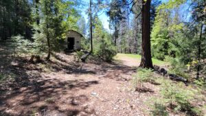
Off The Grid Land For Sale In California – Lot 65 Gogo Rd Ono, CA $85K
Check out the informative YouTube Video for a great boots on the ground feel. Tucked away in a peaceful setting and under a half mile from pavement, this off-the-grid property delivers the kind of privacy, views, and usable land that’s getting harder to find.
Perched high on the property, the approximate 16’x20′ unfinished and unpermitted structure captures sweeping mountain views right from your window and becomes the perfect place to unwind as the sun drops below the horizon. With a loft and attached deck, the space is already framed for comfort and connection to the outdoors. The ”meat and bones” are already in place. A rainwater collection system is present, and the electrical wiring is installed.
Down below, a huge level area opens up opportunity–whether you’re thinking of a building there, recreational use, or simply enjoying a wide open space that’s actually usable.
Also included is a covered and registered trailer that transfers with the property–adding flexibility and potential storage.
Set in an area with good neighbors and quiet surroundings, this is a property where you can truly unplug without feeling isolated.
The 16×20 structure and the covered trailer are unpermitted and may not meet building codes or qualify as a legal residence, so you’ll want to do your own due diligence with the county on what’s possible here. There is no well or septic system and those would be needed by county building standards.
Located at roughly 1,200 to 1,500 feet elevation. There some light CCRS and a road maintenance of just $250 per year, so 4WD is not required. The property is just 27 miles to Redding’s amenities.
Directions: Shown by appointment only to qualified buyers.
APN: 044-100-015-000
| Price | $85,000 |
|---|---|
| Location | Ono, CA |
| Lot Size | 40 Acres |
| Status | For Sale |
Land For Sale In California – 21492 Cove Rd Montgomery Creek 10.4 Acres $99K
Check out the detailed YouTube Video for a great boots on the ground feel. Hidden behind a lockable gate sits a forested mountain property most people will never even know exists. Privacy? You’ve got it. Usability? Already started for you. This isn’t raw, unusable land—you’re stepping into a property that already has two wells—one approximately 50 feet deep and the other around 130 feet, per seller—providing a strong start for your off-grid or rural setup. In addition, a permitted 1,100-gallon septic system is already in place, approved for a 3-bedroom home. With elevations ranging from roughly 2,400 to 2,600 feet, you’ll enjoy noticeably cooler temperatures than the valley below, along with the chance for light snowfall in the winter—just enough to give you that true mountain feel without the extremes. And here’s the kicker… You’re still only about 55 minutes from Redding, CA and around 30 minutes to Burney, CA. So you get true seclusion without being cut off. Not far away is famous Burney Falls with its 129 foot waterfall and hiking trails. Whether you’re looking to build, go off-grid, or lock in a private getaway with key improvements already in place, this is the kind of property people wish they bought years ago. Seller Financing is not available.
Directions: Hwy 299E past central Montgomery Creek. Left on Big Bend Rd go 7.8 mi. Left on Cove Rd go 1.5 mi. Right at first road on right, then stay left and go to end.
APN: 027-390-007-000, 027-390-008-000
| Price | $99,000 |
|---|---|
| Location | Montgomery Creek, CA |
| Lot Size | 10.4 Acres |
| Status | For Sale |

Off Grid Land For Sale In California – 13.2 Acres Jacey’s Tract Rd. Oak Run, CA $99K
Check out the YouTube Video for a great boots on the ground feel. An incredible property with about 800 ft of Little Cow Creek at the back. Has some great potential building sites and a huge seasonal waterfall that flows into Year Round Little Cow Creek. Lots of wildlife here as well. I did not see any CCR’s or HOA’s for this property. In addition, I did not see mineral rights reserved for someone else. Located at roughly 1,700 to 1,900 feet elevation. Captivating natural surroundings, exceptional privacy, and off-the-grid potential set this property apart. It’s an ideal setting for recreation, exploration, a peaceful retreat, or future development. The property is about 28 miles to Redding’s amenities or a few miles if you want a small store with gas available. Follow pink tape path once you get off the neighbors paved driveway if you see the property on your own. Seller Financing is available with about 25% down.
Directions: Hwy 299E toward Round Mtn. Rt on Buzzard Roost Rd go 2.7 mi. Go straight on Phillips Rd .5 mi. Right on Kawean Rd go to end of pavement. Go straight off paved asphalt to the rt of neighbors paved driveway. Follow pink tape down to the property and gate.
APN: 098-550-005-000
| Price | $99,000 |
|---|---|
| Location | Oak Run, CA |
| Lot Size | 13.2 Acres |
| Status | For Sale |

Land Acreage For Sale In California – 37.2 Acres Backbone Rd Bella Vista $99K
Check out the YouTube Land Video for a great boots on the ground feel. 37.2 remote acres with stupendous picture framed views of Lake Shasta and Mount Shasta! There is an awesome seasonal waterfall on the property! This property would make a great weekend get-away or bug out spot. While on the land, a Bald Eagle even flew overhead. This property is fortified with a large shed and an unfinished shell that looks like a cabin on the outside. The shed is 12×24 and built around 2015. The shell structure is 14×40 and built in around 2009. These are not livable structures and given no value. The value is in the land and the amazing views. There are no permits for these structures and there is no well, septic, power or solar on the property. There is room for RV parking. There is some interesting history in the matter that our 30th president, Calvin Coolidge who served from 1923 to 1929 reserved in patent #941271 the mineral rights of this property. The elevation ranges from about 1450 ft to 1620 ft. The property is 4 miles on a dirt road from paved Hwy 299E and the road has seen recent maintenance work but a high ground clearance vehicle is still recommended. It’s about 20 miles from Redding, CA at I-5. There are 10 items listed as CCRS from 2003. Lake Shasta is just over 1 mile away as the Bald Eagle flies. Seller may carry with 1/2 down.
Directions:
Shown by appointment to qualified buyers. Hwy299E from Redding & I-5. From the My T Fine Food Store in Bella Vista, go 9.4 miles to a left just after the Diddy Wells Fire Station, Seamen Gulch Rd go 2.9 mi. Left on Backbone Rd go 1 mi. Left at locked Wilcox Ranch Gate. Go right at all “Y”s in the road.
APN: 097-140-019-000
Approx. GPS:
| Latitude | 40.721117 | Longitude | -122.142734 |
| Price | $99,000 |
|---|---|
| Location | Bella Vista, CA |
| Lot Size | 37.2 Acres |
| Status | For Sale |

Shasta County Land For Sale, 398 Ac Trinity Mountain Road, French Gulch, CA $299,000
Watch the very informative YouTube Land Video. Owner Financing is available for up to 3 years with 25% down. Own a large part of historic French Gulch including about a half mile of Clear Creek. French Gulch was founded by French miners in 1849 and became one of California’s major gold producing areas. There appears to be 2 or more mines on the property along with old creek tailings. The mines are the Dudley and part of the Hughes mine. There are mineral rights according to the title company who researched it for me. I do not know the exact location of the mines or any other details when researching them with the county building department and the title company. Stunning views for miles! Adjoins government land on 3 sides total. Two sides have over 31,000 acres of BLM land and the other side has over 41,000 acres of National Park Service Land. This property was in the 2018 Carr Fire. You pass by Whiskeytown Lake just before you get to the property. It is 15 mi to Redding. The Whiskeytown Lake area has boating, swimming, fishing, a beach, and many hiking trails with 4 leading to awesome waterfalls. I have been to 3 of them and can attest to their worthiness of the hike. The elevation goes from 1300 ft to about 2600 feet and is on both sides of Trinity Mountain Rd. There is a small PGE power station that adjoins the property and has an easement for access and lines.
Directions: At Eureka Way & Buenaventura Blvd go West about 14 mi. Rt on Trinity Mountain Rd. go 1.5 mi to property on rt & left. Property on left ends near Tom Green Mine Rd. PGE station next to pond on rt.
Approx GPS: 40.68593, -122.64076
APN: 046-290-024, 046-290-026
| Price | $299,000 |
|---|---|
| Location | French Gulch, CA |
| Lot Size | 398 Acres |
| Status | For Sale |
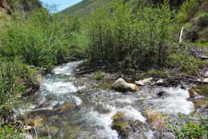
Shasta County Land For Sale 635 Acres French Gulch Rd, French Gulch, CA $299K
Check out the Land Video to see the property in full detail. One full section of mostly steep land but with several great features including power along the bottom road. First, it is completely surrounded on all 4 sides by 6,700 acres of government land. Second, there is at least one spring and over 3/4 of a mile of year round French Gulch Creek! Lastly, there is power to possible build sites with some dirt work. Both roads running though the property are county roads according to the title company. Cell coverage on the upper road. In 1850 French Gulch was one of California’s major gold producers and at least 2 are still active today and located just up the road from the property. Elevation ranges from 1600 feet to 3000 feet at its highest peak. Owner may carry with 20% down for 5 to 10 years.
Directions: Hwy 299W to French Gulch. Right on Trinity Mountain Rd go 2.9 mi. Left on French Gulch Rd go 1 mile to Pink tape and RE sign. Or go 2.6 miles from main road. Left on Tom Green Mine Rd go 1.7 miles.
APN: 046-280-001-000
Approx. GPS:
| Latitude | 40.707086 | Longitude | -122.661558 |
| Price | $299,000 |
|---|---|
| Location | French Gulch, CA |
| Lot Size | 635 Acres |
| Status | For Sale |